If you’ve ever wondered about the difference between GPS and GLONASS, you’re not alone. Many people are curious about these global navigation systems and whether they should use both. In this article, we’ll explore the key distinctions between GPS and GLONASS so you can make an informed decision about which one suits your needs best. Get ready to clear up any confusion and become an expert in understanding the difference between GPS and GLONASS!
Overview

This image is property of cdn.everythingrf.com.
Understanding the Difference Between GPS and GLONASS
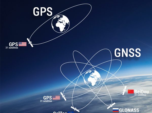
When it comes to navigation systems, two major global navigation satellite systems (GNSS) stand out: the Global Positioning System (GPS) and the Global Navigation Satellite System (GLONASS). While they serve the same purpose of providing accurate positioning and timing information, there are significant differences between the two. Understanding these differences is crucial in determining which system or combination of systems suits your needs best.
The Importance of GPS and GLONASS in Navigation Systems
GPS and GLONASS have revolutionized navigation by providing precise positioning information that is essential in various industries and applications. From personal navigation devices to automotive navigation systems, aviation, marine navigation, and location-based services, GPS and GLONASS play a critical role in ensuring accurate and reliable positioning. By understanding the importance of both systems, you can make informed decisions on how to leverage their capabilities effectively.
Technical Comparison
Technology Behind GPS
GPS is a satellite-based navigation system developed by the United States Department of Defense. It consists of a network of satellites in space, ground control stations, and user receivers. The technology behind GPS relies on trilateration, which uses the distance between satellites and receivers to calculate the position of the receiver accurately. This powerful system operates in six orbital planes and provides coverage to the entire globe.
Technology Behind GLONASS
GLONASS, on the other hand, is the Russian equivalent of GPS. Developed by the Russian Federation, GLONASS follows a similar approach to GPS in providing navigation and positioning services. GLONASS operates using 24 satellites in three orbital planes, ensuring global coverage. Like GPS, GLONASS also utilizes trilateration to determine precise locations and relies on ground control stations to manage the satellite network.
Difference in Signal Frequencies
One notable difference between GPS and GLONASS is their signal frequencies. GPS signals operate in two frequency bands: L1 at 1575.42 MHz and L2 at 1227.60 MHz. GLONASS, on the other hand, uses frequency bands L1 at 1602 MHz and L2 at 1246 MHz. These distinct signal frequencies allow GPS and GLONASS receivers to distinguish between different satellite constellations, enabling simultaneous tracking and improved positioning accuracy when using both systems together.

This image is property of www.symmetryelectronics.com.
Satellite Constellations
GPS and GLONASS differ in the composition of their satellite constellations. GPS consists of up to 32 active satellites, with a minimum of 24 necessary for full global coverage. GLONASS operates with 24 satellites, ensuring comprehensive coverage across the globe as well. However, the differing constellation configurations of GPS and GLONASS mean that there are variations in the distribution and visibility of satellites in different geographical regions.
Accuracy and Coverage Comparison
When it comes to accuracy and coverage, both GPS and GLONASS offer exceptional performance. GPS is renowned for its accuracy, with a typical accuracy of about 5 meters. GLONASS is also highly precise, offering similar performance to GPS in open sky conditions. However, GLONASS exhibits improved accuracy in high latitudes due to its specific orbital configuration, making it a preferred choice in regions closer to the poles. By combining GPS and GLONASS capabilities, users can achieve even higher accuracy and improved positioning performance.
Operational Differences
Number of Satellites
One operational difference between GPS and GLONASS is the number of satellites in their respective constellations. GPS typically operates with a higher number of active satellites, ranging from 31 to 32, ensuring redundancy and backup in case of satellite failures. GLONASS operates with 24 satellites, providing extensive coverage but with a smaller margin for redundancy. The higher number of GPS satellites often translates to better availability and reliability in various scenarios.
Signal Strength and Reliability
Signal strength and reliability can vary between GPS and GLONASS, depending on the receiver’s location. In general, GPS signals tend to have slightly higher signal strength due to the proximity of GPS satellites to the equator. GLONASS, with its orbital configuration, provides stronger signals in high latitude regions, such as northern areas. However, in urban areas with tall buildings and narrow streets, GPS signals often have an advantage due to their ability to penetrate signal-blocking structures more effectively.
Cold Start and Warm Start
A cold start refers to the initialization process when a receiver does not have any prior knowledge or almanac data of the satellite constellation. In such cases, the receiver needs to acquire and decode the satellite signals, which can take some time. GPS receivers generally have faster cold start times compared to GLONASS, as GPS signals are typically stronger and more readily available around the globe. Warm start, on the other hand, refers to the reacquisition of satellite signals after a brief loss of signal. Both GPS and GLONASS excel in warm start scenarios, providing quick reacquisition.

This image is property of www.mobatime.com.
Time to First Fix (TTFF)
Time to First Fix (TTFF) is the duration it takes for a receiver to acquire enough satellite signals and calculate a position fix. GPS receivers generally offer faster TTFF due to the higher number of available satellites and stronger signal strength. GLONASS, however, can offer comparable TTFF performance in high latitude regions due to its stronger signals in those areas. By using both GPS and GLONASS together, users can benefit from faster and more reliable TTFF in various scenarios.
Battery Consumption and Power Efficiency
Power efficiency is an essential consideration when using navigation systems, particularly in battery-powered devices. GPS receivers are generally more power-efficient compared to GLONASS, as GPS signals require less power to acquire and track. GLONASS signals, with their higher frequency bands, tend to consume more battery power. However, advancements in technology have led to the development of power-efficient dual-constellation receivers, minimizing power consumption while reaping the benefits of both GPS and GLONASS.
Benefits of GPS
Global Availability
GPS has an unparalleled global availability, covering nearly every corner of the planet. With 24 to 32 active satellites at any given time, GPS ensures that users can access precise positioning information wherever they are. Whether you’re hiking in remote mountains or navigating in bustling cities, GPS provides the backbone for accurate and reliable navigation.
Long-Term Reliability
Since its inception, GPS has cemented its reputation for long-term reliability. With decades of operation and continuous updates, the GPS system has proven its stability and dependability. GPS signals are constantly monitored and adjusted to maintain accurate positioning information, ensuring that users can rely on GPS for their navigation needs today and in the future.
Robust Performance in Dense Urban Areas
Urban environments often pose challenges to navigation systems due to the presence of tall buildings and signal-blocking structures. GPS, with its lower frequency signals, exhibits robust performance in dense urban areas. GPS signals can penetrate buildings and urban canyons more effectively, providing reliable navigation even in challenging urban scenarios.

This image is property of www.e-education.psu.edu.
Integration with Various Devices and Applications
Thanks to its widespread adoption and standardization, GPS has seamlessly integrated into various devices and applications. From smartphones and smartwatches to automotive navigation systems and wearable fitness trackers, GPS is a common feature across a wide range of consumer electronics. This integration enables users to leverage GPS for navigation, tracking, location-based services, and a myriad of other applications.
Benefits of GLONASS
Improved Accuracy in High Latitude Regions
One significant advantage that GLONASS offers over GPS is its improved accuracy in high latitude regions. GLONASS satellites are distributed in such a way that they provide higher visibility and better positioning performance in areas closer to the poles. This makes GLONASS particularly advantageous for users operating in northern areas, such as Alaska, Scandinavia, and Russia.
Increased Number of Satellites
While GPS often operates with a higher number of active satellites, GLONASS is catching up. With a total of 24 satellites in its constellation, GLONASS provides comprehensive global coverage and redundancy. The increased number of active GLONASS satellites contributes to the system’s reliability, ensuring that users can maintain accurate positioning even in challenging environments.
Better Coverage in Northern Hemisphere
If your navigation requirements primarily involve the northern hemisphere, GLONASS can offer better coverage compared to GPS. When used alone or in conjunction with GPS, GLONASS provides improved visibility and availability of satellites in northern regions. This enhanced coverage translates to more accurate and reliable positioning, particularly for users operating in subpolar and polar areas.
High Signal Strength in Urban Canyons
In urban areas with towering buildings and narrow streets, GPS signals can experience degradation due to signal obstructions. GLONASS, with its stronger signals in high latitude regions, tends to provide higher signal strength in urban canyons. This advantage makes GLONASS an attractive choice for users navigating dense urban environments where signal blockage is a common challenge.
Combining GPS and GLONASS

This image is property of www.e-education.psu.edu.
Dual-Constellation Receivers
To fully leverage the benefits of both GPS and GLONASS, dual-constellation receivers have become increasingly popular. These receivers can simultaneously track and process signals from both GPS and GLONASS satellites, offering improved positioning performance. By combining the strengths of both systems, users can achieve higher accuracy, faster time to first fix, and enhanced reliability in various scenarios.
Improved Positioning Performance
By offering more satellites and multiple signal sources, the combination of GPS and GLONASS enhances positioning performance. Dual-constellation receivers can leverage the increased number of visible satellites from both systems, leading to better satellite geometry and improved accuracy. This combination proves especially valuable in challenging environments, including urban areas and locations with obstructed views of the sky.
Redundancy and Resilience in Navigation
Dual-constellation support provides redundancy and resilience in navigation systems. In the event of satellite outages, having two independent satellite systems significantly reduces the risk of losing positioning capability. If one system experiences issues or signal degradation, the other system can compensate and ensure uninterrupted navigation. This redundancy is particularly crucial in safety-critical applications such as aviation and marine navigation.
Challenges and Limitations
While combining GPS and GLONASS offers numerous benefits, there are also challenges and limitations to consider. Dual-constellation receivers may require hardware and software updates to support both systems effectively. Additionally, integrating two satellite systems can increase complexity and cost. It is essential to ensure compatibility and robust performance of the receiver with both GPS and GLONASS signals to fully reap the advantages of the dual-constellation approach.
Applications of GPS and GLONASS
Automotive Navigation Systems
GPS and GLONASS form the backbone of today’s automotive navigation systems. By providing accurate positioning and real-time navigation data, these systems guide drivers with turn-by-turn directions, live traffic updates, and points of interest. The combination of GPS and GLONASS enables faster and more reliable navigation, ensuring drivers reach their destinations efficiently and safely.
Aviation and Aeronautical Applications
In aviation and aeronautical applications, precise and reliable positioning is crucial for safe and efficient flight operations. GPS and GLONASS play a vital role in aircraft navigation, providing accurate position, velocity, and timing information to pilots and air traffic control systems. The integration of GPS and GLONASS enhances situational awareness, improves navigation services, and enables smooth operation of air traffic management systems.
Marine Navigation and Positioning
GPS and GLONASS are essential tools in marine navigation, enabling accurate positioning, tracking, and route planning for ships, boats, and other maritime vessels. From recreational boating to commercial shipping and offshore operations, GPS and GLONASS support safe and efficient maritime navigation. The combination of both systems enhances reliability, particularly in areas with obstructed views of the sky or challenging environmental conditions.
Location-Based Services and Geocaching
Location-based services (LBS) have become ubiquitous in our daily lives, thanks to GPS and GLONASS. Mobile devices and applications leverage the precise positioning capabilities of these satellite systems to offer location-aware services. From finding nearby restaurants and attractions to geocaching adventures, GPS and GLONASS enable personalized and context-aware experiences based on the user’s location.
Future Trends and Developments
Emerging Global Navigation Satellite Systems (GNSS)
Beyond GPS and GLONASS, additional GNSS systems are emerging. The European Union’s Galileo and China’s BeiDou Navigation Satellite System (BDS) offer multi-constellation capabilities, further enhancing positioning accuracy and resilience. With multiple GNSS systems in operation, the future of navigation will involve seamless integration and interoperability across these systems, enabling even greater accuracy and reliability.
Multi-Constellation Receivers
As GNSS systems continue to expand, multi-constellation receivers are gaining prominence. These receivers can simultaneously track signals from multiple satellite systems, such as GPS, GLONASS, Galileo, and BeiDou. By combining the strengths of various GNSS systems, multi-constellation receivers offer enhanced performance, improved accuracy, and increased availability of satellites.
Integration with Galileo and BeiDou
GPS and GLONASS are not standalone systems anymore. Integration with other GNSS systems, such as Galileo and BeiDou, further enhances navigation capabilities. Combined, these systems offer augmented satellite visibility, improved accuracy, and increased reliability. The integration of multiple GNSS systems creates a global navigation infrastructure that ensures positioning continuity even in challenging scenarios.
Advancements in Positioning Technology
Advancements in positioning technology continue to drive the evolution of navigation systems. From improved receiver sensitivity and signal processing algorithms to advanced positioning techniques like Real-Time Kinematic (RTK) and Precise Point Positioning (PPP), the future of navigation holds promises of higher accuracy, faster TTFF, and robust performance in any environment. These advancements will redefine navigation across industries and empower new applications.
Conclusion
Understanding the differences between GPS and GLONASS is crucial in choosing the right navigation system for your needs. While GPS offers global availability and long-term reliability, GLONASS excels in high latitude regions and provides better coverage in the northern hemisphere. By using both GPS and GLONASS together, users can reap the benefits of improved accuracy, faster positioning, and enhanced reliability.
Dual-constellation support through receivers capable of tracking GPS and GLONASS signals simultaneously takes advantage of the strengths of both systems. The combination provides redundancy, resilience, and improved performance in challenging environments. Whether you’re navigating on the road, flying in the sky, sailing on the seas, or exploring the outdoors, GPS and GLONASS play essential roles in ensuring accurate and reliable positioning. The future of navigation lies in the integration and advancements of multiple GNSS systems, promising even greater accuracy and capabilities.